The United States has many major rivers. These rivers are very influential in the geography, economy, and ecosystems of the United States. Many rivers are wildlife habitats, from migratory birds to fish species. U.S. rivers also played a significant role in shaping history as they are transportation routes for Indigenous people and early settlers.
Many of the rivers in the United States carry huge quantities of water discharged, the volume of water output through rivers into oceans, lakes, and other rivers. Amongst which are highly notable the Mississippi River, Ohio River, and the Saint Lawrence River.
1. Mississippi River
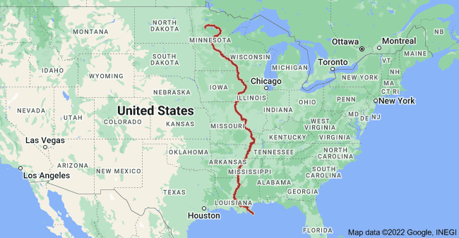
Mississippi is the largest river in the United States with an average discharge of roughly 593,000 cubic feet per second (cfs) at its mouth, the Mississippi River has the largest discharge of any river in the United States. It is one of the most important streams in the world for trade, agriculture, and ecology because of its enormous drainage basin, which covers 31 states. It supports a flourishing fishing sector and vast wetlands as it flows into the Gulf of Mexico. The calculation of the discharge excluding the Atchafalaya-Red River basin.
Discharge (cfs): 593,000
Drainage area: 1,150,000 sq miles in the U.S and Canada
Source: Lake Itasca
Source Location: Itasca State Park, Clearwater County, Minnesota. 47°14′23″N 95°12′27″W
2. Ohio River
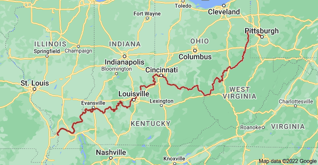
The Ohio River, located in the southern United States, has the second-largest discharge. Flows through or borders six states — Illinois, Indiana, Kentucky, Ohio, Pennsylvania, and West Virginia. Tributaries drain water from parts of nine additional states1. The river’s depth varied from about 3 to 20 feet. It has dams and reservoirs. Known as the “Gateway to the West,” it is a crucial waterway for transportation and supplies drinking water to millions.
The Ohio River is a vital resource, supplying drinking water to over five million people. Additionally, nearly 25 million people, about 10% of the U.S. population reside within the Ohio River Basin, highlighting its importance to the region’s livelihoods and ecosystems. The 20 dams along the river are under the management of the Army Corps of Engineers.
Discharge (cfs): 281,500
Drainage area: 203,000 sq miles
Source: Allegheny River
Source Location: Allegany Township, Potter County, Pennsylvania. 47°14′23″N 95°12′27″W
3. Saint Lawrence River
It is the third-largest river in the United States, with a discharge rate of 275,000 CFS of water emptying at the US-Canada border. The St. Lawrence River flows beside Gananoque, Brockville, Morristown, Ogdensburg, Massena, Cornwall, Montreal, Trois-Rivières, and Quebec City before draining into the Gulf of St. Lawrence.
The St. Lawrence River flows 744 miles from Lake Ontario into the Gulf of St. Lawrence, with 114 miles located in New York State. It reaches a depth of 250 feet at its deepest point. Serving as a bi-national waterway, it provides drinking water to communities on both sides and supports a tourism-driven economy. Known as Highway H2O, the river is the second largest in Canada and the third largest in the U.S.
Discharge (cfs): 275,000
Drainage area: 258,000 sq miles
Source: Lake Ontario
Source Location: Kingston, Ontario / Cape Vincent, New York. 44°06′N 76°24′W
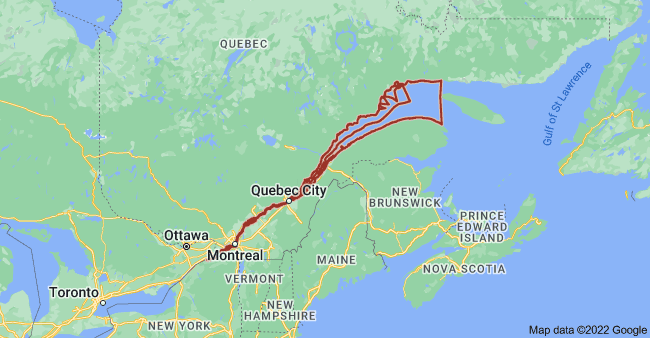
4. Columbia River
Columbia is one of the largest and longest rivers in the USA. The river originates in British Columbia’s Rocky Mountains. It runs northwest and then south into Washington, then heads west to form the majority of the border between Washington and Oregon before draining into the Pacific Ocean. its largest tributary is the Snake River. Its drainage basin stretches over seven US states and one Canadian province.
Discharge (cfs): 273,000
Drainage area: 258,000 sq miles
Source: Columbia Lake
Source Location: British Columbia, Canada. 50°13′35″N 115°51′05″W
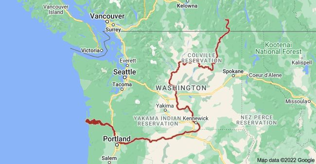
5. Yukon River
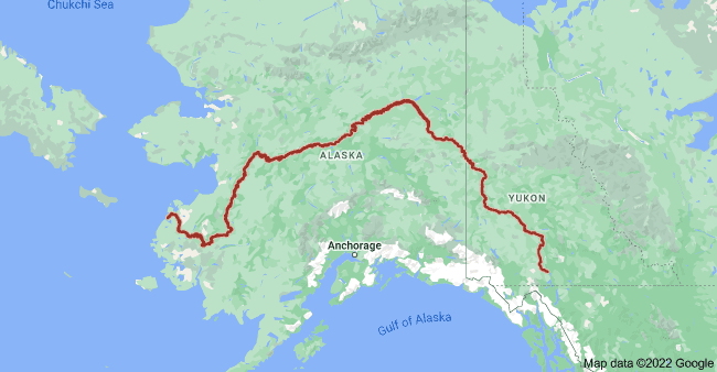
It runs across the Canadian territory of Yukon., (Yukon is Canada’s territory named after the river). Yukon River is the longest in Alaska and Yukon territory. The 75% half of the river flows westward through the state of Alaska in the United States.
The Yukon River, stretching over 3,190 kilometers (1,982 miles), flows through Alaska (USA) and Yukon (Canada). It features stunning natural landscapes, including rugged mountains and vast wilderness. Main cities along the river include Whitehorse and Dawson City in Canada, and Fairbanks in Alaska (USA). The river is a waterway for transportation, supports diverse wildlife, and is historically significant for the Klondike Gold Rush.
Discharge (cfs): 227,000
Drainage area: 328,000 sq miles
Source: Llewellyn Glacier
Source Location: Atlin District, British Columbia, Canada. 59°10′N 133°50′W
Here, we listed 50 rivers by average discharge.
| No | River | Length (km) | Average discharge (cfs) (ft3/s) | Mouth |
|---|---|---|---|---|
| 1 | Mississippi River | 3,730 | 593,000 | Gulf of Mexico (Pilottown, Plaquemines Parish, LA) |
| 2 | Ohio River | 1,575 | 281,500 | Mississippi River (Cairo, Illinois / Ballard County, Kentucky) |
| 3 | Saint Lawrence River | 965 | 275,000 (In U.S. side) | Gulf of Saint Lawrence (Quebec, Canada) |
| 4 | Columbia River | 2,000 | 273,000 | Pacific Ocean (Pacific Ocean, at Clatsop County, Oregon) |
| 5 | Yukon River | 3,185 | 227,000 | Bering Sea (Kusilvak, Alaska, U.S.) |
| 6 | Atchafalaya River | 220 | 225,000 | Gulf of Mexico (Morgan City, Louisiana) |
| 7 | Niagara River | 58 | 204,700 | Lake Ontario |
| 8 | Detroit River | 51 | 188,000 | Lake Erie |
| 9 | St. Clair River | 63 | 183,000 | Lake St. Clair |
| 10 | Missouri River | 3,767 | 86,300 | Mississippi River |
| 11 | St. Marys River | 120 | 75,000 | Lake Huron-Lake Michigan |
| 12 | Tennessee River | 1,049 | 68,000 | Ohio River |
| 13 | Mobile River | 72 | 67,000 | Gulf of Mexico |
| 14 | Kuskokwim River | 1,130 | 67,000 | Bering Sea |
| 15 | Red River | 2,190 | 58,000 | Atchafalaya River |
| 16 | Copper River | 470 | 57,400 | Gulf of Alaska |
| 17 | Snake River | 1,674 | 55,000 | Columbia River |
| 18 | Stikine River | 610 | 56,000 | Pacific Ocean |
| 19 | Susitna River | 504 | 51,000 | Gulf of Alaska |
| 20 | Arkansas River | 2,322 | 44,500 | Mississippi River |
| 21 | Tanana River | 940 | 41,800 | Yukon River |
| 22 | Susquehanna River | 747 | 38,200 | Chesapeake Bay |
| 23 | Willamette River | 301 | 37,400 | Columbia River |
| 24 | Wabash River | 810 | 34,500 | Ohio River |
| 25 | Alabama River | 512 | 32,500 | Mobile River |
| 26 | Nushagak River | 450 | 32,000 | Bering Sea |
| 27 | Alsek River | 386 | 31,000 | Gulf of Alaska |
| 28 | Cumberland River | 1,120 | 30,000 | Ohio River |
| 29 | Black River-Ouachita River | 974 | 29,800 | Red River |
| 30 | White River | 1,159 | 29,500 | Mississippi River |
| 31 | Pend Oreille River | 210 | 27,000 | Columbia River |
| 32 | Tombigbee River | 320 | 26,300 | Mobile River |
| 33 | Koyukuk River | 684 | 25,000 | Yukon River |
| 34 | Illinois River | 439 | 24,000 | Mississippi River |
| 35 | Sacramento River | 719 | 23,500 | Pacific Ocean |
| 36 | Porcupine River | 916 | 23,000 | Yukon River |
| 37 | Colorado River | 2,330 | 22,000 | Gulf of California |
| 38 | Clark Fork River | 500 | 21,900 | Pend Oreille River |
| 39 | Hudson River | 507 | 21,900 | Atlantic Ocean |
| 40 | Yentna River | 121 | 21,000 | Susitna River |
| 41 | Chitina River | 180 | 20,000 | Copper River |
| 42 | Allegheny River | 523 | 19,900 | Ohio River |
| 43 | Apalachicola River | 80 | 19,602 | Gulf of Mexico |
| 44 | Connecticut River | 655 | 18,400 | Atlantic Ocean |
| 45 | Kvichak River | 80 | 17,900 | Bering Sea |
| 46 | Klamath River | 423 | 17,300 | Pacific Ocean |
| 47 | Santee River | 230 | 17,000 | Atlantic Ocean |
| 48 | Skagit River | 240 | 16,500 | Pacific Ocean |
| 49 | Kootenai (Kootenay) River | 781 | 27,600 | Columbia River |
| 50 | Coosa River | 450 | 16,000 | Alabama River |


